Quarrying
Whats on this page?
Introduction
Introduction
Heli-Tele empowers quarry managers and teams with cutting-edge technology to boost efficiency, maintain precise stock control, and enhance on-site safety. By leveraging drone-based data collection and advanced analytics, quarries can operate smarter, faster, and with greater confidence
Efficiency
Efficiency
Faster Surveys, Better Insights
A Heli-Tele drone flight takes just a few hours—far quicker than traditional surveying methods that can take several days. This means the data you need is available faster, supporting quicker decision-making and smoother operational workflows.
Stock Control
Stock Control
Accurate Inventory Management
Heli-Tele delivers precise volume measurements of stockpiles, enabling managers to monitor materials in real time. This enhanced visibility simplifies forecasting for blasting volumes and helps maintain optimal inventory levels, ensuring you always have the resources you need.
Safety
Safety
Reduced Risk, Enhanced Awareness
With Heli-Tele, fewer workers are required to enter hazardous areas. Drone-based inspections keep teams informed while remaining safely out of harm’s way. The result is a safer work environment, where critical insights are obtained remotely without compromising safety standards.
The Online Portal
The Online Portal
Complete Site Coverage, Anytime, Anywhere
Managing your survey data is simple and seamless. Our service provides high-accuracy terrain models, delivering centimetre-level Digital Surface Models (DSMs) and Digital Terrain Models (DTMs) for precise measurements and calculations. With detailed 3D visualisation, you can explore high-resolution models to inspect rock faces, equipment locations, and site conditions with ease.
Collaboration is effortless, allowing you to store multiple site locations and survey sessions while tailoring access for different roles. Team members can review data, highlight key details, and share insights, ensuring everyone stays informed. When needed, survey data can be exported smoothly for use in planning, design, or integration with other systems.
With quick access to reliable data, making informed decisions has never been easier.
Planning & CAD Integration
Planning & CAD Integration
From Blueprint to Reality
Heli-Tele seamlessly integrates with CAD (DXF) drawings, enabling managers to compare planned designs with real-world progress on-site. This allows deviations to be identified early, helping to avoid penalties from issues such as overcutting. For blasting operations, high-resolution 3D imagery reveals critical geological details, while the blasting tool provides precise forecasts of material yields.
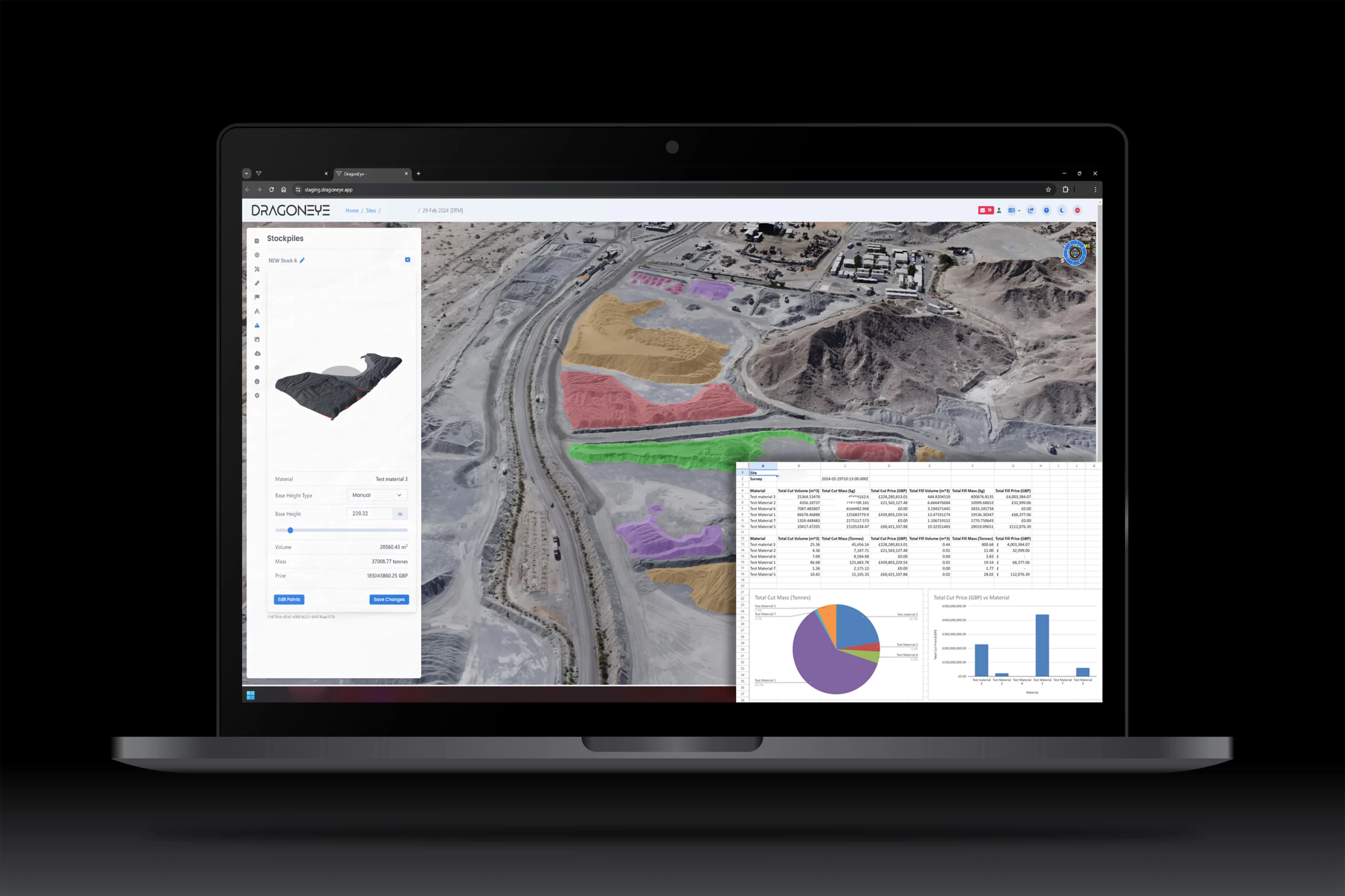
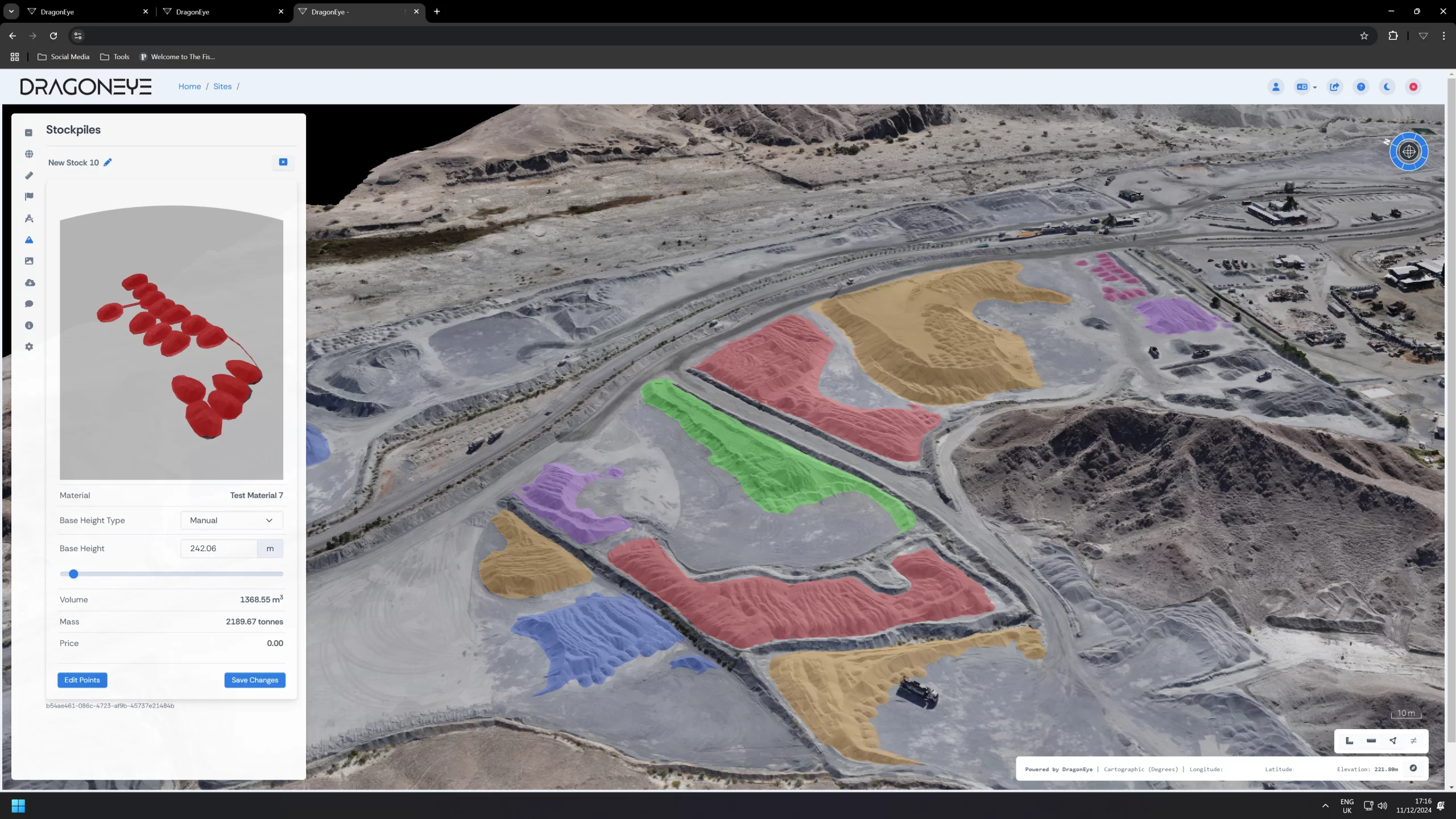
Quarry Operations & Stockpiles
Quarry Operations & Stockpiles
Measurable Value, Actionable Insights
Heli-Tele’s Stockpile module allows managers to monitor the mass, volume, and value of materials over time. Each survey produces a detailed PDF report containing historical imagery, topographical data, and valuations. Additionally, this data can be exported to third-party financial and administrative systems, streamlining inventory management and accounting processes.
Roadway Tool & Fuel Efficiency
Roadway Tool & Fuel Efficiency
Optimising Your Infrastructure
With Heli-Tele’s Roadway tool, managers can monitor road gradients and conditions. Optimising haul roads helps reduce fuel consumption and lower operating costs an increasingly vital consideration given legislative changes, such as the United Kingdom’s transition away from duty-free “red” diesel.
Health, Safety & Compliance
Health, Safety & Compliance
Building a Safety First Culture
The 3D models generated by Heli-Tele are invaluable for training and onboarding. New employees and contractors can gain a virtual understanding of the quarry layout, potential hazards, and best practices before arriving on-site. Operations teams can also remotely inspect bunds and rockfall traps, reducing staff exposure to hazardous environments and expediting essential repairs.
Environmental Monitoring
Environmental Monitoring
Sustaining the Land Around You
Heli-Tele supports ongoing environmental commitments with tools designed to monitor and protect the environment. The Terrain Comparison tool tracks erosion and land stability in non-production areas, while environmental specialists can perform virtual inspections of habitats, vegetation, watercourses, and waste storage areas. This proactive approach ensures compliance, safeguards wildlife, and helps maintain ecological balance.
Dispute Resolution
Dispute Resolution
Historical Data at Your Fingertips
Heli-Tele retains all historical imagery and survey data, providing a reliable archive for verifying contractor work, resolving disputes over material deliveries or removals, and confirming the accuracy of completed groundworks. With Heli-Tele, you benefit from transparent, verifiable records that promote trust and accountability.