A Significant Shift in Survey & Mapping

Heli-Tele provides a comprehensive solution for capturing, processing, viewing, inspecting, measuring, assessing, and sharing high-quality survey data collected by drone. Delivered by industry experts and hosted on secure, state-of-the-art cloud infrastructure, our service ensures precision and reliability.

Comprehensive, Accessible, and Practical Tools

Comparisons

Compare many aspects of projects survey to survey & survey to plan.

Including

  • Heatmap comparison
  • 3D Direct comparison
  • Cross section comparison
  • Volume comparison
  • Survey to Survey
  • Survey to Plan

Measurement Tools

Measure anything you can see using a point, line, or polygon. 

Including

  • Elevation History
  • Cross Section
  • Bund Check
  • Road Grade
  • Distance Check
  • Height Difference
  • Volume
  • Cut & Fill

Volumes & Stock

Our surveys include the ability to measure volume stock or blast volumes and more.

Including

  • Blast Volume Analysis
  • Stock Pile Measurements
  • Stock Pile Reporting
  • Material Listing
  • Cut and Fill Against Plan
  • Cut & Fill Average
  • Ground Plain Analysis

Capture and Interact with your Survey Projects in 3D.

Heli-Tele specialises in wide-area surveys, including large tracts of land under development, quarries, and agricultural sites. We also provide close-range inspections of buildings and other infrastructure, ensuring detailed and accurate results.

Data Aquisition

We offer comprehensive professional drone flight planning and data acquisition services through our network of accredited pilots. By combining traditional methods with cutting-edge techniques, we ensure results with centimetre-level accuracy.

Processing

Using professionally captured images and precise positioning data, we create centimetre-accurate models through advanced photogrammetry techniques and state-of-the-art technologies.

View and Inspect

View your survey or inspection in 3D with our secure cloud-hosted, browser-based solution. The Browser based system provides many forms of tools and reports to make use of.

Measure

Perform a variety of point, line, area, elevation, volumetric and thermal measurements on a captured subject, which when adopted into a workflow greatly improve many aspects.

Compare and Contrast

See the evolution of a site over time by comparing survey to survey, or compare construction progress with an imported plan with the ability to use both 3 dimensional models and line drawings.

Report and Share

Build a material stockpile report, a dynamic risk assessment or condition report of a building or infrastructure and share your findings with other members of your team, or contractors.

Proud to Use Dragoneye for Delivery

Industries

Construction

We can bring massive benefit within construction Projects, streamlining workflows, improving planning, and saving time and money across the board.

Construction

Click Below to find a case study in how Heli-Tele are helping to streamline construction projects, and reducing costs.
Full Detail

Building Inspection

Heli-Tele specialises in building inspections and is currently assisting a major insurance group in risk assessment. We ensure that nothing is overlooked, providing comprehensive and reliable results.

Insurance

Read this case study to find out how Heli-Tele collects and presents data for a large insurance group giving greater visibility on risk evaluation.
Full Detail

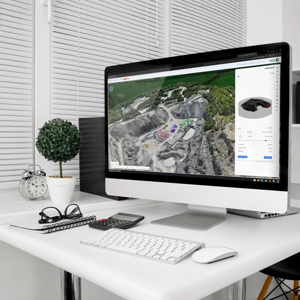
Quarry and Gravel Pits

Heli-Tele has been collaborating with leading quarry companies across England and Wales for many years. Our tools help reduce costs while providing detailed progress reports.

Quarrying

Read about our long standing relationship with one of the largest Aggregate companies in the country, and find out the diverse ways in which they use Heli-Tele and the Data we provide.
Full Detail

Want to Know More?

Why not book a Demonstration, and find out how Heli-Tele can help with your projects

Want to Know More?

Why not book a Demonstration, and find out how Heli-Tele can help with your projects